Feeds:
Posts
Comments

Archive for the ‘Trails’ Category

I don’t even know how to talk about my recent experience hiking to the summit of Mount Whitney, the highest peak in the contiguous United States at 14,505 feet. It was amazing, challenging, surreal, and, in a word: epic. It ranks as one of the hardest physical challenges I’ve ever faced, and that’s saying a lot after running eight full marathons. As my husband Mike said, I wouldn’t call it “fun,” although it was euphoric when we reached the top. The problem is that when you reach the top, you still have 11 miles to hike back down to the bottom. I’m glad we did it. I’m glad we learned some things along the way.

This adventure all started when my oldest daughter Shannon declared her desire to climb Mount Whitney (and then graduate to climbing all of the seven summits — the highest peaks on all seven continents, which she set her sights on after reading the wonderful book No Summit Out of Sight (Amazon affiliate link, but I highly recommend this book for girls and boys ages 10 and up and all adults)).

Road to Whitney Portal

The road to Whitney Portal — mixed emotions as we faced hiking that mountain range!

I was intimidated by the thought of climbing Mt. Whitney, and rightly so. We had climbed Mt. Baldy twice (10,064 feet), including a night hike to see the Perseid meteor shower and watch the sunrise on the peak. We hiked Mt. San Jacinto (10,833 feet). And we would have hiked the other of the big three peaks in Southern California — Mt. San Gorgonio — if the entire wilderness area had not been closed due to fire damage (it’s since been reopened). We ran the Yosemite Half Marathon as part of our training. We attended an REI class (no affiliation) as part of our preparation. I read the book One Best Hike: Mount Whitney. We entered the lottery in February/March to get a permit to climb the mountain, but we didn’t win a permit (only 35% of applications are successful). Finally as the date neared and other people canceled their reservations, Mike secured three overnight permits to hike the Mt. Whitney Trail (and then we showed up at the Eastern Sierra Interagency Visitor Center to trade for a same-day permit to enter the area on Monday, August 27 and summit on my 47th birthday, Tuesday, August 28).

Mount Whitney view from parking lot

The intimidating view from the parking lot at the Mount Whitney trail head at Whitney Portal.

After securing our permit at 11:30, getting lunch and driving up to Whitney Portal, we hit the trail at 1 p.m.

hikers on Mt. Whitney trail

Mike, me and Shannon on the trail

We hiked the first 3.8 miles slowly to start, knowing that the elevation gain from 9,000 feet at the Whitney Portal to 10,400 feet at Outpost Camp could be hard on people coming from sea level. We reached Outpost Camp around 4 p.m. and felt great. In retrospect, we should have camped there for the night, but we figured we might as well continue on to Trail Camp at 12,000 feet another 2.3 miles up the trail. (In hindsight, if we had had more time, we should have acclimated at 10,000+ feet for 1-2 days before heading out on the trail — we didn’t realize how much we would be affected by altitude sickness). Unfortunately, the next two challenging, technical miles took 2.5 hours, and we ended up stopping just short of Trail Camp to camp at Consultation Lake, a gorgeous spot that’s not nearly as crowded and I highly recommend, as long as you have the right tent and sleeping bags to withstand any wind and cold at that location.

Consultation Lake hiker August 2018

Shannon at Consultation Lake on the Mt. Whitney Trail

We set up camp alongside the lake. It was cold at 6:30 p.m. and we were all feeling the effects of mild altitude sickness — headache and slow moving.

tent at Consultation Lake

Our solo campsite at Consultation Lake as the sun set on the mountain range.

In our altitude sickness haze, Shannon and I thought Consultation Lake was actually called “Consolation Lake,” as in the lake was the consolation prize if you did not actually make it to the peak of Mount Whitney! It was such a gorgeous spot to camp and I’m glad we stopped there before hiking another half a mile to Trail Camp.

We slept fitfully at altitude and waited until sunrise to get going.

Sunrise consultation lake

Sunrise at Consultation Lake, looking back toward Lone Pine.

Moon set over Mt. Whitney range

Moon setting over the mountain range at dawn.

In retrospect we should have awoken at 4 or 5 a.m. and gotten on the trail. We thought we’d have plenty of time to hike 5.4 miles to the summit by 1:30 p.m. (the recommended turn-around time if you haven’t made it to the summit).

We stopped at Trail Camp to filter some water for the ascent. A clever chipmunk outwitted us and snuck into one of the open back packs, which led to the best quote of the hike: “A chipmunk stole my birth control pills!”

Chipmunk at Trail Camp I guess the little critter had been conditioned to learn that food comes in plastic containers, and the white plastic pack looked as good as any other food. We managed to move some rocks and rescue the pills before the guy had a chance to gnaw his way through the pack! We also saw marmots and a pika on the trail!

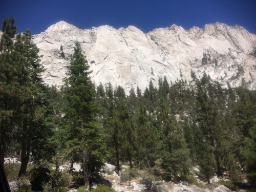
The mountain range became more and more intimidating and impressive.

Whitney range

Impressive mountain range with amazing deep blue skies.

Whitney over Trail Camp

View from Trail Camp

On the way up the infamous 99 switchbacks, we saw icicles on the rocks and pink snow pack on the mountainside.

IMG_0314

IMG_0310

We could see back to Consultation Lake as we gained elevation.

IMG_0315

One of my favorite parts of the hike was just after the Trail Crest, when you enter Sequoia National Park and look over parts of the park that you can only see from the Mt. Whitney Trail or John Muir Trail.

Trail Crest Mt. Whitney

Shannon and me at Trail Crest, overlooking Sequoia National Park.

Finally at 1 p.m. we reached the summit, 14,505 feet.

Mt. Whitney summit plaque

Me, Shannon and Mike by the plaque at the summit.

I asked everyone at the summit (about 10 people) to sing Happy Birthday to me. Mike gave me a special birthday gift, a Mt. Whitney survey medallion to hang on the Christmas tree. Shannon took this photo of me with a sign that happened to be made by another Angela who was also turning 47 in another two weeks!

Mt. Whitney summit hiker

Mount Whitney, 14,505′, August 28, 2018

We were the 88-90th hikers of the day to sign the log book at the Mt. Whitney summit shelter.

IMG_2156

There are no photos of us hiking the 11 miles down the mountain. We reached Consultation Lake again around 5 p.m. and packed up camp. Unfortunately, I would have liked to have been done with the hike right about then. We still had another 5.6 miles to go, though. It went considerably slower than we anticipated, due to continuing altitude sickness and just plain tired legs. The problem was that we went slower due to altitude sickness (both to try to prevent it and to fight it off) and that meant more time on our legs. I think we trained adequately for the hike but would have been much happier had we acclimated for a day or two at 10,000+ feet before starting the hike (given that we live at sea level). But we only had two days to do it (thank you Grandma for watching our other two girls for two days while we hiked!) and we did the best we could with the time we had. I’m still sore a week later (calves mainly) but am back to working out and have my sights set on San Gorgonio and Half Dome next!

Have you hiked Mt. Whitney or is it on your bucket list? What other hikes are your highest and/or most recommended? Whitney was amazing and I’ve never seen the sky look so blue. I’d say go for it if you’ve always wanted to climb it, just make sure to do your homework and spend time acclimating first if you need it!

Read Full Post »

Did you ever sign up for a race months in advance, and then those months flew by and you wondered what you were thinking when you signed up for that race? That happened to me when I signed up for the Yosemite Half Marathon.

Yosemite Half Marathon 2018 logo

Had I known months ago that May was going to be so busy for me, I wouldn’t have signed up. And yet, I’m so glad I did, because I loved the race and I loved spending Mother’s Day weekend with my husband and three daughters in Yosemite National Park!

On Friday afternoon we drove seven hours up to the historic Big Trees Lodge (formerly the Wawona Hotel) inside the park. We used our fourth grade “Every Kid in a Park” national park pass to get into the park for free, saving $30, hooray!

Wawona Hotel Big Trees Lodge porch view

After sitting out on the 2nd floor porch and admiring the night sky, we got to bed by 10:30 p.m. and got a whole 4.5 hours of sleep before our race day alarm went off at 2:50 a.m.! I was running the race with my husband Mike and oldest daughter, 16-year-old Shannon. We needed to leave by 3:20 a.m. to make the 35-minute drive to the shuttle bus parking lot at Sierra Star in Oakhurst by 4 a.m. There wasn’t a coffee maker in our hotel room but thankfully the Big Trees Lodge staff agreed to have the night manager make us some coffee at 3 a.m.! He insisted that we take a whole thermos and a cup of cream! I was so appreciative. We ate muffins and bananas in the car on the drive.

We arrived at Sierra Star by 4 a.m. but faced a line of cars waiting to park in the field. It took 15 minutes or so for us to get parked. I was happy to see a row of porta potties set up in the field, along with very nice buses equipped with toilets. We got on a bus by 4:20 a.m. for the ride to the starting line. Unfortunately, our bus driver got lost, we took a 25-minute detour out of our way, and the ride ended up taking 1 hour 20 minutes total. I didn’t mind waiting on a warm bus (and Mike and Shannon both slept), but we got to the starting area around 5:40 a.m. and still had to pick up our bibs and drop our gear before the 6 a.m. start! (Can you hear my famous last words on Friday night, “Oh, we don’t need to go to the expo at Bass Lake Recreation Area; we’ll have an hour at the starting line to pick up our bibs”?) I waited in line to pick up our bibs while Mike hit the porta potties, then he grabbed a gear bag for drop-off at the starting line and we rushed over there with literally 45 seconds to spare. The race was chip timed so it would have been absolutely fine to miss the 6 a.m. start for the first heat (unless you were competing to be a top finisher and wanted an overall award based on your gun time — that wasn’t us!), but we were eager to go.

Race day weather could not have been better with clear sunny skies and temperatures in the low 40s at the start and warming up as the time progressed and the course descended in elevation to the finish at Bass Lake Recreation Area. I think the temperature must have been in the high 60s when we finished just after 8 a.m. I wore long pants and a long-sleeved shirt and wish I would have worn some gloves but my husband and daughter were perfectly fine in shorts and a short-sleeved t-shirt (go figure).

The course runs outside the national park itself but has its own spectacular scenery. I loved running through the woods on the dirt fire road for the first five miles of the course. It’s not an “easy” course by any means — the road was rutted and rocky in places but I thought that made it interesting and fun and the miles clicked by faster than any other race I’ve done. The mountain dogwoods were in full bloom and were so beautiful scattered among the pine trees. The only problem (and it wasn’t really a problem) was that my Garmin lost reception for about 0.4 miles among the trees so it wasn’t recording my mileage or split times accurately, saying we were running a slower pace than we actually were. Then we hit a downhill section from miles 6-10 on a paved road. My daughter and I both loved that section best. We cranked out mile splits in the low 8s and it felt easy. Then we hit the flat and rolling section from miles 10-13.1 and it got tough, as any half marathon gets tough at that point. The race director had warned us that we would hear the finish line across Bass Lake when we still had a ways to go, so we were prepared for that. I loved running in to the finish at the lake. Shannon and I crossed the finish line together at 2:04:50 and 2:04:51, earning her 2nd place in her 15-19 age group out of 9 runners! Unfortunately, in the rush at the starting line to get my bib, use the porta potties, and drop my gear bag, I had pinned on my husband’s bib instead of mine! So as I crossed the finish line, a very confused announcer read out, “And here are Shannon White and, um, Michael White, from La Habra!” Yeah. Oops. Thank goodness I had not run fast enough to qualify for an age group award and the correction of my time did not mess up the awards for the first five to finish in the 45-49 age group. Mike finished a few minutes later after a couple of porta potty stops along the course.

At the finish we received a huge, really nice medal with an image of Yosemite on it, along with a cold protein shake (choice of three flavors) and a box of post-run and hiking snacks.

Yosemite Half Marathon 2018 finishers medals

Me, Mike and Shannon in line for the shuttle bus back to the parking area. You can see Bass Lake behind us. Mike has on the technical shirt given out at the race. And yes, Shannon is wearing my Kappa Kappa Gamma sweatshirt from 1989!

If you wanted to make the weekend even more challenging you could participate in one or more of the official race “club hikes” and earn an extra medallion for taking those hikes and sending in photos. Instead, we rented bikes and road around the park with our younger children.

IMG_7201

Mike and my younger daughters even braved the 45-degree water in the river.

IMG_7203

We also drove up to Glacier Point, stopping at this lookout for my 13-year-old ballerina to pose in an arabesque.

IMG_9920

It was sunny and gorgeous in the valley but cold with even a few snow flurries at Glacier Point! The cool thing is that Mike and I cross-country skied to Glacier Point in 1998 before we had any children. It felt surreal to re-visit that spot 20 years later with our three daughters.

I usually do not do the same race twice, but I’d do the Yosemite Half again for sure. If you want to do it, sign up early enough to decide if you want to reserve a spot to camp at the finish line at Bass Lake, and then train on some trails and downhill runs to get ready for the course. Decide if you’re going to run it for fun or run it to race, and adjust your expectations accordingly.

Have you visited Yosemite? Have you run this or any other Vacation Races half marathons?

Read Full Post »

My husband Mike and I have a long history of crazy outdoor sports adventures over our 29 years together (next year we celebrate the 30th anniversary of our first date as high school sweethearts!) Riding mountain bikes 17.5 miles around the single track Potawatomi Trail in Pinckney Recreation Area in Michigan? No problem! Snowshoeing up Mount Kearsarge in the White Mountains in New Hampshire? We were back in time for a delicious dinner at the hotel. Flying in a glider over Oahu? Um, yes, but maybe not so many acrobatic tricks? Cross-country skiing all 21 miles roundtrip to Glacier Point and back in Yosemite National Park? I cross-country skied as a kid in the midwest, surely I could make it? (We did make it, but I have never been so sore in my life – worse than post-marathon soreness). Scuba diving in the Pacific Ocean off Kauai? No need for prior experience! Waterskiing behind our very own jet boat on Lake Mohave on the Colorado River? The cold water took my breath away but we loved it. Riding 34 miles on the Kal-Haven rail trail from Kalamazoo to South Haven in one day, staying overnight at a hotel and riding 34 miles back the next day? The hotel shuttle driver thought for sure we would be begging for a ride back and he could charge us an exorbitant fare, but the bike ride back the second day might have been easier than the first day’s ride!

So when Mike suggested that we hike Mt. Baldy (more formally known as Mount San Antonio) in the dark at 1 a.m. so we could view the Perseid meteor shower and then watch the sunrise from the peak, I readily agreed. We had hiked Mt. Baldy once before in the daytime in August 2015 and even dragged along our daughters who were 7, 10, and 13 at the time (pro tip (actually, crazy amateur tip): 7 is a little young to hike Mt. Baldy – not only is it a long day trip, but I had to keep a literal death grip on my 7-year-old’s hand to keep her from slipping off the Devil’s Backbone and other treacherous sections of the trail). Mt. Baldy stands out as the highest peak in the San Gabriel Mountains.

I set my alarm for 11:30 p.m. and tried unsuccessfully to go to bed at 8:30 p.m. We got out the door by midnight and arrived at 1 a.m. at Manker Campground and the trailhead (we chose to walk up the fire access road to the Ski Hut Trail, across Baldy Bowl to the summit, then loop back down across Devil’s Backbone to the Baldy Notch, where you can take a chairlift down to save yourself four miles of hiking). The hike up from the trailhead to the peak is four-and-a-half miles but we managed to add nearly half a mile when we lost the trail in the dark a couple of times. With snack stops and meteor-viewing breaks, it took us four hours to reach the summit at 10,064 feet. We had to hang out there for an hour before the sunrise, and unfortunately it was windy and cold at the peak. This was the view for the entire hour before the sun rose up over the horizon:

Pre-dawn on Mount Baldy summit

And here is the sunrise at about 6 a.m.:

Mt. Baldy sunrise

We were grateful to see the sun come up not so much for the colorful sunrise display as for the warmth the sun brought!

At 6:40 a.m. we started our descent along the Devil’s Backbone. There are some hazardous sections along the ridge, but they seemed easy compared to the hike up in the dark!

IMG_7881

My 15-year-old and me on the Devil’s Backbone trail

At certain points it felt like we were on another planet with the sparse, rocky terrain above the tree line.

Devil's Backbone trail

We reached the lodge at Baldy Notch three miles later in about 1 hour 50 minutes. We paid $15 each for a one-way ticket down the chairlift (not that they checked that we paid, but I was happy to be honest about it). Then we had a half-mile walk back to our car at the trailhead. We ended up hiking a total of about nine miles in six-and-a-half hours. We did several things right (took maps of the trail, appropriate hiking boots, packs, headlamps with extra batteries, and plenty of water, juice, Gatorade and snacks), and learned that we should prepare better for severe cold and winds on the summit.

If you want to do this hike, either in the daytime or at night, do your homework by reading all about the trails on hiking sites like Trail to Peak, and be sure to check the weather conditions not for the village of Mt. Baldy but for the summit itself! This hike is best done in summer when all the snow has melted, but serious mountaineers do attempt it in the winter. Sadly, there have been several deaths on Mount Baldy in the past few winters.

Stay tuned for more posts on mountaineering, because my 15-year-old and I are training to hike Mount Whitney (the highest peak in the 48 contiguous states) next summer! We are taking an informational class at REI (not an affiliate link) in September to learn how to apply for a hiking permit and what exactly we need to do to get ready. And as part of our training, we are hoping to run a marathon together in the spring (maybe the Eugene Marathon? Most marathons require the entrants to be at least 16 years of age so we are looking at races in late April or early May 2018).

Have you hiked Mt. Baldy or Mt. Whitney? Ever run the Eugene Marathon? Thoughts and opinions please!


Read Full Post »

Two more weeks until Boston! What happened to March and how can it be April already? The past three months since I started working part-time as a substitute aide in the special education classrooms have gone by in a blur of working and training. I think I’m ready for Boston but it doesn’t feel like I’m ready because I’ve squeezed in my training around a very erratic, unpredictable work schedule (if I leave my phone on overnight I will often get a call at 5:30 a.m. to work at 8:30 a.m. that same day). Training has been a priority, just not top priority and that seems to be allowing the taper crazies to get to me a little more this time around (Boston will be full marathon number 7 for me).

Last week was spring break and I took the week to focus on a very important part of my training — altitude training! I’m kidding — my family likes to ski so we went to the mountains in Whistler, British Columbia.

IMG_3151

Apparently I’m not the only one who likes to joke. I saw this sign on my run through Stanley Park in Vancouver.

I skied for four days and got in some pretty serious workouts trying to keep up with my kids (ages 13, 11 and 7), all of whom are better skiers than I am. This was one of my favorite trails, a traverse along the Whistler Peak:

IMG_3129

Swapped a gorgeous ski trail for a running trail that day!

I made sure to get some running in though too. Check out the moon above Whistler just as the sun was rising over the Valley Trail:

IMG_3125

Five miles at an 8:15 pace along the Valley Trail. The cold morning encouraged me to run at a brisk pace!

I also ran 10 miles on the Seawall Trail in Vancouver.

IMG_3150

What a treat to do a long run as a tourist in beautiful Stanley Park in Vancouver, British Columbia. I saw many other runners that Saturday morning and I wondered how many of them would also be going to Boston in a couple of weeks!

Now I’m back home and back to reality. I started a second part-time job grading online California state assessment tests. Good thing the training schedule is lighter in these last couple of weeks before Boston! One six-miler for my long run this weekend and before I know it, I’ll be back in Beantown. (I lived there for two years when Mike went to business school at MIT Sloan. It’s where my 13-year-old was born, and where my 11-year-old took her first steps when we went back for a visit 10 years ago!)

Do you like to ski? Have you ever been to Boston? Where should I go to eat when I’m there? We have our old favorites and are definitely planning to go for brunch in the South End (Aquitaine. [ETA — closed for renovations! We now have reservations at Gaslight.]) and Italian in the North End (not sure which restaurant yet. [ETA: Rabia’s!]).

Read Full Post »

Twenty-five days until Boston! I say that with a combination of excitement and nervousness. I’m at that point in the 20-week training cycle where all the hard work of training has started to wear on my body and spirit, so the doubts creep in. “If I’m struggling this hard to maintain race pace for eight miles, how will I ever do it for 26.2 miles?” and “That 20-miler was tough — I can’t imagine adding 6.2 miles on to that!” But then I remind myself about about the concept of periodization (dividing training into phases that build toward peak performance on race day) and the magic of taper (those last two to three weeks of reduced training that result in fresh legs for the race), and I trust that I am doing what I need to do to have the best race possible.

To keep myself motivated in this last month before Boston, I’ve taken advantage of some travel to run new routes in interesting places. When my husband and oldest daughter wanted to watch the tennis matches at Indian Wells, I made sure to get in a 10 mile run in Palm Springs.

IMG_3008

I could see a dusting of snow on top of the mountain as I headed out on my run from Ruth Hardy Park in Palm Springs.

I started my run at 11:00 a.m., which was very good practice for Boston. I’m in the third wave, which starts at 10:50 a.m. EDT. I prefer an early morning run or race, but I didn’t have any trouble on the 10 miles at that later time of day.

My next opportunity to “vacarun” (“traveljog”? “runtour”?) came when I transported 5th graders on a field trip to Rancho Soñado in Silverado, California. Parents didn’t need to stick around during the science lessons, so I drove to nearby Irvine Regional Park and headed out on the trails for eight miles.

First I picked the aptly named “Road Runner Loop.”

IMG_3052

Irvine Regional Park is home to a grove of heritage Oak and Sycamore Trees.

What a treat to find views like this in the middle of a densely populated suburban city.

IMG_3054

There is a zoo in the park, but I didn’t have to pay admission to see some wildlife! On the Horseshoe Loop Trail, I saw a bobcat!

3019158526_315339e85f_z

Not the bobcat I saw, but it looked much like this. Photo credit: dbarronoss.

Apparently my survival instincts need a little honing, because my first thought was, “What is a cat doing on the trail?” Once realization dawned on me that this wasn’t an overgrown house cat (doh!), my second thought was, “I need to get a picture of it!” Thank goodness that bobcat wanted nothing to do with me and didn’t stick around for its photo opportunity. I finally had the good sense to Google “What should I do if I see a bobcat?” Answer: Back away slowly. Don’t run or it might chase you! Make lots of noise. Spray it with water if necessary.

I walked very slowly around the next bend in the trail and there it was again! This time I stood still and watched it go right back through the brush to its original position on the trail. Once it was out of sight, I slowly walked along the trail until I thought it was safe to start running again. Whew! Thank goodness the last few miles were uneventful and the only creatures I saw were horses and people.

What’s the “wildest” creature you’ve seen in the wild?

I’ve seen bears (from a safe distance) in the national parks.

Where’s your favorite place to run or hike?

I’ve got to stick with the national parks here — I’ve had some fun adventures in Zion and Joshua Tree National Parks.

Read Full Post »

Two months have passed since my husband lost his job. One month has passed since I started working as a substitute aide in special education classrooms. I’ve gotten a special education in the past four weeks for sure! I’ve worked at five schools and taught in classrooms ranging from kindergarten to 8th grade. I’ve taught a roomful of 30+ kids in general education and worked one-on-one with kids with Down Syndrome, autism, and ADHD. I’ve worked an average of 20 hours per week and maintained a workout schedule of 8-10 hours per week on top of that.

There are 11 weeks to go in the training schedule before Boston! Training is going well although I cannot say I am enjoying it as much now that I am having to squeeze it in around a very fluid work schedule. I might plan an 8-mile tempo run for Friday morning and then get a call at 7:15 a.m. asking me to substitute from 8:30-2:30. So how do I fit it all in? Here are five tips I’ve developed over the last four weeks.

1. Consider two-a-days. I’ve split an 8-mile run into four miles outside with my teenage daughter in the morning before work followed by four miles on the treadmill in the afternoon before dinner. It wasn’t fun but it was oh-so-satisfying to get the full mileage in for the day.

2. Be flexible. I don’t mean work on touching your toes, I mean be willing to move a cross-training day from Tuesday to Friday as need be. Or if it’s forecast to rain on Sunday (take that, California drought!), move that long workout to Saturday instead of Sunday. Trade a bike ride out for an Insanity DVD. Count yard work as your strength training for the day.

Gorgeous, rain-free day for 23 miles on the ElliptiGO on the San Gabriel River Trail.

Gorgeous, rain-free Saturday for 23 miles on the ElliptiGO on the San Gabriel River Trail.

3. Be forgiving. If you can’t get the full mileage in for the day, it’s a little tempting to write the day off entirely. But it’s way better to run 5.6 miles instead of 7 than to run 0 miles. I know it stinks to run 5.6 miles and be disappointed (hello – 5.6 miles is dang far), but it will feel a lot better to put those miles in and cross off the day than to leave that blank space on the training log.

4. Remember why you are training. Yes, I am training for a big goal race (Boston) but I am in this one for fun and for the experience. I actually enjoy the training and the satisfaction of checking off my workouts more than I enjoy a big goal race. So when I’ve had a hard day at work (think: kid running out of classroom, biting himself, crying, or refusing to communicate with me) I remind myself how much better I will feel if I get out on the road and zen out on a run.

5. Shake things up. I’ve been running for nearly five years now! I started in March 2011 when I was training for my first sprint triathlon as I approached age 40. It’s wonderful to look back on all the milestones — the first times I hit each new distance or ran a new race. But honestly? I am burned out on a lot of my local running routes! So after a hard day at work today, I came home at lunchtime and asked my husband to help me map out a new route for my 8-mile tempo run. And we chose a hilly trail/road route, and I chose to be flexible (see #2 above) and switch out 8 road miles at 8:00 pace for 8 trail/road miles with lots of elevation gain at 10:00 pace.

Just one of the hills on my 8-mile trail/road run today.>

Just one of the hills on my 8-mile trail/road run today.

The miles flew by as I was distracted by views of the ocean on one side:

That little bright line is the Pacific Ocean between Long Beach and Catalina Island

That little bright line is the Pacific Ocean between Long Beach and Catalina Island.

and the cacti near me on the other side and the snow on the mountains in the distance:

Not a bad winter day.

Not a bad winter day.

Do you have any advice for fitting workouts in around a work schedule?

Read Full Post »

I first saw the ElliptiGO elliptical bicycle when world champion runner Mary Decker Slaney was riding one before the Santa Barbara Wine Country Half Marathon in 2014. I was too tired and shy to go up to her at the finish line expo after the race (note to self: “Hi! It’s so nice to meet you! What do you have here?” would have done very nicely). Anyway, I had been dying to try an ElliptiGO ever since. Recently my curiosity boiled over when I listened to this Runners Connect podcast with Darren Brown, a 3-time All-American, sub-4:00 miler, and marketing manager for ElliptiGO.

So I reached out to the nice people at ElliptiGO and they hooked me up with Hermosa Cyclery in Hermosa Beach, California. Located just steps from a spectacular beachside bike path, Hermosa Cyclery offers ElliptiGOs for sale or rental.

IMG_2678

Gorgeous day to ride an ElliptiGO 8S along Hermosa Beach!

I rode the ElliptiGO 8S (similar to the new model 11R, which retails for $3,499) and you can rent one from Hermosa Cyclery starting at just $20 an hour. My husband Mike tried out the ElliptiGO 3C (retail price $1,999). The verdict? We absolutely loved them! I cannot remember the last time I’ve had so much fun working out.

After a one-minute demonstration of how to ride the elliptical bike, my husband and I hopped on ours and went! It took no time at all for us to master riding the ElliptiGO. Getting started is easy — just step on one pedal and you’re off!

Shifting gears is exceptionally smooth (more smooth than a road bike, which my mechanical engineer husband says is due to the internal geared hub) and braking is the same as a road bike. I had no trouble balancing; in fact the ride felt very stable.

The first day we headed south on the beach path and rode for over 45 minutes total down to the end of the path and back. I could have sworn we were only out for 30 minutes at the most. It felt like we were sightseeing from an 8-foot tall vantage point. I could easily bike and enjoy the view along the way. The funny thing is, we were the main attraction along the path! Pedestrians, runners and road cyclists all stared at us, smiled, and even cheered! I got thumbs-up and clapping as we rode.

The next morning Mike and I headed north on the path. The Strand is also known as the Martin Braude Bike Path and it runs 22 miles and connects with other bike paths. We rode from 14th Street in Hermosa Beach up to Marina del Rey. There is a small section of stairs, and I impressed the guys behind me by lifting the lightweight bike and carrying it up the stairs on my own. There are also some slight hills on this section, and we powered right up them (and enjoyed coasting down them)!

With stops for water along the way, we ended up riding for two hours at about a 10 mph pace (cruising and enjoying the sights — we could have gone significantly faster if we pushed it). The ElliptiGO offers an excellent aerobic and strength training workout. By the end of two hours, I felt it in my outer quads, glutes, and a little in my lower back. On Sunday my marathon training plan for Boston called for a 10-mile long run, and the ElliptiGO ride more than satisfied the equivalent of that run.

The ElliptiGO makes for the ideal cross-training for runners because it offers a low-impact workout that closely mimics the motion of running. Standing upright eliminates the strain on your neck and back that you might feel tucking in for a long road bicycle ride, and saves your rear end from saddle soreness! Plus you get the joy of exercising outside rather than being stuck inside the gym.

I want to thank Hermosa Cyclery for the opportunity to test the ElliptiGO bikes. I’m telling Santa I want an ElliptiGO for Christmas, and if I don’t get one, I will definitely rent one for another fabulous workout on the beach path!

(I was not compensated for my honest review of the ElliptiGO and Hermosa Cyclery.)

Have you ever ridden an ElliptiGO? Are you interested in trying one out?

Read Full Post »

For my fifth (?!) round of full marathon training I’ve kicked it up a notch and taken on the competitive marathon training plan from Smart Marathon Training. To be honest, it’s kicking my behind. It didn’t help that my youngest daughter got sick, as in so sick that she needed my help a few times a night to steam her up in the bathroom so that she could breathe and recover from her croup-like cough and chest congestion. Then, of course, in my sleep-deprived state, I came down with the cold/cough too, albeit in a much milder form. So the last few weeks have been a muddle of trying to juggle sick kids, sick me, and the rainy (?!) weather here in Southern California. Today the training plan called for 80 miles on the bike. I mapped out a loop from my house that stayed off the roads as much as possible, taking the Santa Ana River Trail to the Huntington Beach Path to the San Gabriel River Trail and back on the Whittier Greenway. It came out to 73.3 miles and I called it good.

The 73.3-mile bike loop I mapped out on MapMyRun.

The 73.3-mile bike loop I mapped out on MapMyRun.

I left at 7 a.m. just after the sun rose and I completed the first half in just over two hours. The second half proved much more challenging. I went from a relatively easy 3:20 pace to a tough 4:00-4:20 pace as I went back uphill (slightly) into the wind. My legs and lungs were fine but I do most of my biking on the spin bike so I wasn’t used to holding my head up with my helmet on, and now my neck and back are really sore!

It proved to be an absolutely gorgeous day out though and I have no complaints. I’m so lucky to be able to get out on the bike in mid-December, and to have family members that support me on a bike ride that took 5 hours and 24 minutes (including all the stops at stop lights and for water refills etc.) On my ride I saw an incredibly wide range of things:

– The Christmas tree farm where we cut down our tree each year.

– A strawberry field.

– Angel Stadium.

– The Pacific Ocean, and lots and lots of surfers!

– Oil drilling platforms and massive cargo ships from China. 😦

– Catalina Island. 🙂

– From the beach I had the best view of the snow-capped mountains in the east behind me.

– The naval ammo base in Seal Beach.

– Pelicans skimming across the top of the water over the San Gabriel River as they hunted for fish.

– It was 47 degrees F when I started my ride at 7 a.m. and the best chalk sign I saw on the beach path was “The cold never bothered me anyway!” No matter that I couldn’t feel my toes for about 2/3 of the ride. Note to self: wear wool socks and consider investing in bike shoe booties!

When I got home I immediately refueled with some leftover rouladen baked by my wonderful mom who was in town visiting from Idaho. My favorite meal and the perfect mix of protein and carbs when paired with some leftover mashed potatoes! I took an ice bath (much as I didn’t want to) and propped my legs up while wearing some compression socks. I’m not taking any chances here!

What did you do on your workout(s) this weekend? What’s the longest swim/bike/run/walk you’ve ever done?

Read Full Post »

Each summer for the past three years, my family has gone to family camp for a week at Lair of the Golden Bear.

Pinecrest Lake

Pinecrest Lake

It is hands-down the best family vacation for the dollar (let’s put it this way: not cheap but worth every penny). The tiny town of Pinecrest, California is nestled in the Sierras in Northern California. At an elevation of 5,700 feet, it’s just a smidge higher than Boulder, Colorado. The air is clear and the oxygen is thin compared to sea level where I live in Southern California. Training at elevation is not easy but it’s oh-so-rewarding (according to Runner’s World there are a lot of Benefits of Altitude Training for Non-Pro Runners). I definitely had to adjust my expectations and run according to time and effort rather than according to mileage (i.e., I ran slower than I’d like but I put in the same effort and ran for the same amount of time as usual).

During that week at camp, I exercised every day:

Running: 3 runs for a total of 20.25 miles
Biking: 2 bike rides for a total of 21.17 miles
Yoga: 2 sessions for 45 minutes each
Kayaking: 1 session for 45 minutes
Horseback riding: 1 session for 45 minutes
Stand-up paddle boarding (LOVE): 1 session for 45 minutes
Strength training: 1 session (on the beach!) for 20 minutes

That means that I packed in 10 hours of exercise for the week and had a ton of fun in the process! I even got to exercise with my husband and kids for several of those activities (my 12-year-old accompanied me to yoga class, kayaking and stand-up paddle boarding, and my 9-year-old went kayaking and horseback riding with my husband and me).

I went for two trail runs and on the second run around Pinecrest Lake I stopped several times to take photos:

The dirt trail bordering Pinecrest Lake

The dirt trail bordering Pinecrest Lake

Dam, that’s a nice dam!

Pinecrest Lake Dam

(Full disclosure: right after I crossed that bridge and hit the dirt trail again, I literally hit the dirt trail. I did a “Superman” when my trailing foot clipped a rock and I went flying through the air, landing on my right shoulder and right hip. I wasn’t hurt so much as my pride was injured).

I hung in there though and was rewarded when the trail looked like this:

Pinecrest Recreational Trail marker

Pinecrest Recreational Trail marker

Here’s the marker close up:

Love it when a trail requires these markers pounded into the rock face.

Love it when a trail requires these markers pounded into the rock face.

So, the fact that I went on vacation with my family for a week did not mean that I slacked on marathon training. I kept up the training plan and had a great time in the process!

Where’s the most interesting place you’ve exercised in the past few months? Pinecrest is the best but I’m looking forward to a 20th wedding anniversary trip to Napa Valley soon and I expect to get in a run and maybe a bike ride too!

Read Full Post »

Southern California is gorgeous, don’t get me wrong. But after I’ve run the same routes, hills, tracks, trails and treadmills over and over again, I get a little bored. That’s part of the reason I rarely run the same race twice. I like to run someplace new and it’s such a privilege to get to run on a closed course.

Lately when I get bored, I just think back to my spring break trip and pretend that I’m here:

Malaekahana Bike Path Laie

That’s the Malaekahana Bike and Pedestrian Path from La’ie to Kahuku on the North Shore. It’s a wide, paved path that runs for a little over a mile next to Kamehameha Highway. I ran along it my last morning on Oahu. Everyone should have a chance to run there and then take a cooldown walk along a beach like this:

Laie Oahu

Those clouds make it look dramatic and cold but it was balmy and peaceful in the early morning hour after my run.

Read Full Post »

Older Posts »